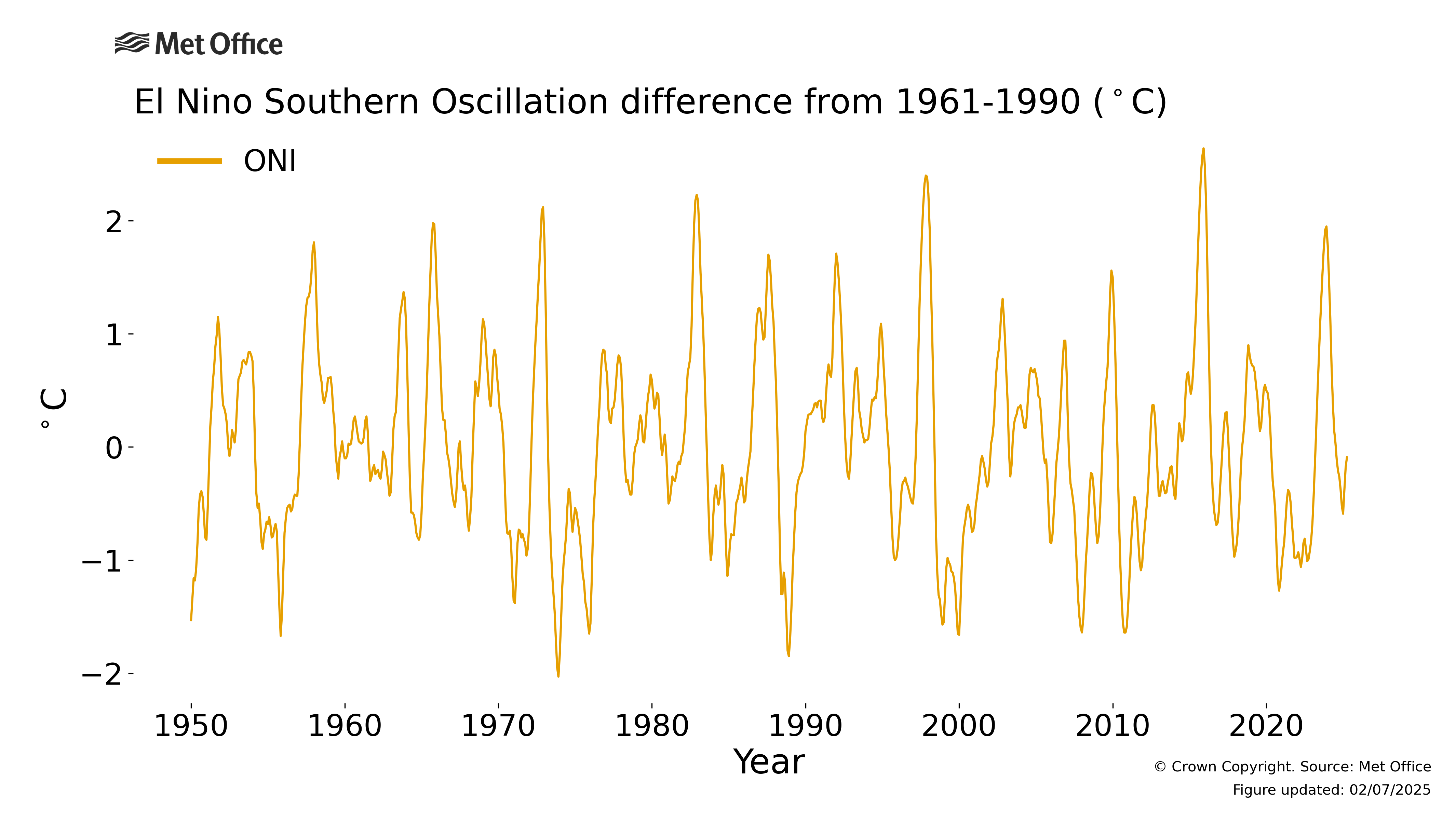
ENSO - El Niño Southern Oscillation
The name 'El Niño' is widely used to describe a warming of the sea-surface that occurs every few years in the central-to-eastern equatorial Pacific. 'La Niña', El Niño’s colder sibling, is the term adopted for episodes of cooler-than-normal sea surface waters in the equatorial Pacific.
El Niño and La Niña events arise spontaneously from strong interactions between the ocean and atmosphere. They lead to widespread changes in the climate system that can last several months, and have significant impacts.
El Niño and La Niña episodes occur in an irregular year-to-year cycle called the El Niño Southern Oscillation (ENSO). “Southern Oscillation” refers to atmospheric pressure changes between the eastern and western tropical Pacific that accompany both El Niño and La Niña episodes in the ocean. The sea-temperature and pressure changes act to reinforce each other, sustaining a fully developed El Niño or La Niña event. ENSO is the dominant feature of climate variability on inter-annual timescales.
Research shows that the El Niño and La Niña cycle has impacts all over the world. For example, El Niño is a factor that can increase the risk of colder winters in the UK. We now have a clearer view of these impacts and can reproduce many of them in our climate models.
El Niño and La Niña have far reaching consequences.
NAO - North Atlantic Oscillation
The term 'North Atlantic Oscillation' refers to variations in the large-scale surface pressure gradient in the North Atlantic region.
In the average state of the atmosphere, the North Atlantic surface pressure is relatively high in the subtropics at latitudes 20°N to 40°N ('the Azores High'), and lower further North at latitudes 50°N to 70°N (the 'Icelandic Low'). The North-South pressure difference determines the strength of the westerly winds across the Atlantic, particularly in the winter, and fluctuations in this difference are known as the North Atlantic Oscillation (NAO).
When the pressure difference is larger than average, the NAO is said to be in its positive phase. Westerly winds are stronger, and storms tend to be stronger too. They are generally more frequent, and they travel across north-western Europe. When the pressure difference is smaller than average, we say that the NAO is in its negative phase. In this case the storm track can be weakened and diverted across southern Europe.
The NAO is associated with changes in temperature and rainfall in Europe and North America. It is related to the Arctic Oscillation, which is a measure of large-scale pressure variation across the whole of the northern hemisphere.
Fluctuations in the NAO occur on a wide range of time-scales. There are day-to-day changes associated with the passage of individual weather systems, and slower changes associated with seasonal and longer-term variability stretching out over years and even decades.
AMO - Atlantic Multidecadal Oscillation
The Atlantic Multidecadal Oscillation (or AMO for short) is also known as Atlantic Multidecadal Variability (AMV). It has two phases, a positive phase where sea-surface waters in the North Atlantic are warmer than average and a negative phase when they are colder than average. There are a number of ways of calculating an AMO "index" which depend on the way that the longer-term trend seen in the observed record is dealt with.
It is not entirely clear what causes changes in the AMO. Long records of the AMO can be gleaned from non-instrumental sources, and these suggest that it is a long-lived natural fluctuation generated spontaneously within the ocean-atmosphere system. However, there is also evidence that switches in phase can be driven by changes in the output of manmade pollution.
The different phases of the AMO have been associated with a variety of impacts. The positive phase has been associated with reduced Arctic sea ice, melting of the Greenland ice sheet, increased hurricane activity in the North Atlantic and increased rainfall over the Sahel region of sub-Saharan Africa. As for the cold, negative phase, it has the opposite impacts: cooling at high latitudes, reduced hurricane activity and a drier Sahel.
PDO - Pacific Decadal Oscillation
The Pacific Decadal Oscillation, or PDO for short, is a term used to describe climatic variations over vast areas of the Pacific Ocean over periods of 20 to 30 years. At shorter time scales, there is some overlap between the PDO and other high-frequency variability such as ENSO. Therefore, the PDO series is typically smoothed to remove high-frequency variability and emphasise the slower changes.
As with the other modes, the PDO has positive and negative phases. In the positive phase, a cool eye of surface waters in the central North Pacific is surrounded by warmer surface waters in a horse-shoe shape running from the tropics round the eastern edge of the eye and then to the north. In the negative phase, this pattern is reversed. In the tropics, the pattern is similar to the typical patterns of El Niño and La Niña albeit somewhat broader in latitude.
There are a number of apparent "shifts" in the PDO between the two phases, which occur around 1925, 1945, 1976 and 2000. The shift from the positive to negative phase around 2000 has been associated with a recent slowdown in the rate of global temperature change. The exact causes of the "shifts" are unknown and may be due to a combination of different mechanisms acting at different time scales.


